

Jomolhari Loop Trek – 9N/10D
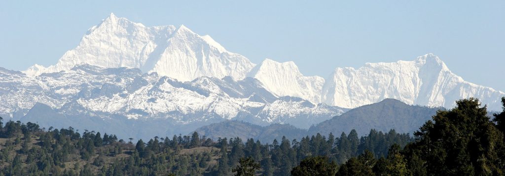
Jomolhari Loop is the shortest of the Jomolhari trekking routes, which are the most popular treks in Bhutan. With altitude differences of 2,500m and nearly 5,000m it offers a wide range of landscapes, fauna and flora. The highlight of this trek is the spectacular view of Mount Jomolhari from Jomolhari Base camp (Jangothang).
Trekkers who want to avoid high passes and high altitude can chose an easier version of the Jomolhari Loop by retracing their steps from Jangothang (see days 1-3), while still having the majestic impressions of Mount Jomolhari.
Bhutanese society with unique culture, traditions and appearance. The trek also offers a day of relaxation at the famous Gasa hot springs that is sure to rejuvenate you.
This is one of the more difficult treks offered in Bhutan due to the high altitudes and steep ascents and descents along the path. The best seasons to complete this challenge are in April-June and Mid-September-Mid-November.
Max Elevation: 5, 005 m
Min Elevation: 2,500 m
Difficulty: Medium
Season: April, May, June, September, October, November
No. of Days: 7 Days
Day 01: Arrival at the Paro International Airport. The Traveller Trails – Bhutan’s representative will receive and transfer to hotel.
Later in the afternoon,
- National Museum
- Paro Dzong
- Drukgyel
- Experience true authentic Bhutanese farm house
In the evening, scroll down to Paro town
Overnight Paro
Day 02: Paro – Hike to Tiger Monastery
Hike to Tiger Nest Monastery as good acclimatisation for the trek
Overnight Paro
Day 03: Paro - Gunitsawa Village – Sharna Zampa
Distance | 40minutes |
Time | 40 Minutes |
Ascent | 80m |
Camp Altitude | 2,850m |
This trek begins at Gunitsawa Village were you pass the army post. At the army check post your trek permit (provided by your tour operator) will be checked and endorsed. The campsite is on the opposite side of the river, not far from Gunitsawa.
Day 04: Sharna Zampa - Thangthangkha.
Distance | 22 km |
Time | 7-8hours |
Ascent | 770m, descent 10m |
Camp Altitude | 3,610m |
On this long day, the trail continues with lots of small ups and downs. After going uphill through the river valley the valley finally narrows gradually to a mere path which descends to a meadow where a camp will be set up. From here, if weather permits, you will have the first great view of Mt. Jomolhari.
Day 05: Thangthagkha - Jangothang
Distance | 19km |
Time | 5-6hours |
Ascent | 480m |
Camp Altitude | 4,080m |
If you did not see Mt. Jomolhari the previous evening, you will still have a chance to get a great view early this morning. This morning the trek continues up the Paro Chhu valley which widens into patches of alpine meadow and scanty growths of forest. You will cross an army checkpoint along the way and enjoy a spectacular view of high mountain ridges and snow-capped peaks. In this area yaks and their herder’s homes become a regular feature of the landscape. Passing the villages Soe, Takethang and Dangochang is another asset on this day. After reaching Jangothang, one of the most beautiful campsites of the Himalayas, you will again have a spectacular view of Mount Jomolhari.
Day 06: Jangothang Halt.
Distance | .......... |
Time | .......... |
Ascent | ........ m |
Camp Altitude | ........ m |
The rest day in Jangothang provides plenty of possibilities for day hikes with great views of lakes and snow capped mountains such as Jomolhari and Jichu Drake. There are good chances to spot some blue sheep on the upper slopes of the valley. Jangothang is a perfect environment for your acclimatization. You can also trek up to Tosoh or hike around the area. There are good short hiking trails in three directions. Jomolhari and its subsidiary mountain chains lay directly west, Jichu Drakey to the north and there are a number of unclimbed peaks to the east.
Day 07: Jangothang - Soi Yaktsa
Distance | 16km |
Time | 6-7hours |
Ascent | 810m, descent 1,090m |
Camp Altitude | 3,800m |
The trail leads to a last settlement in the valley and drops to the Paro Chhu. Passing the lake of Tshophu (4,380m) you will climb up steeply to Bhonte La pass at 4,890 m, the highest point of this trek route. Reaching the Dhumzo Chhu River, you trek downstream passing the few houses of Soi Yaktsa (Dhumzo) to arrive at your camp soon after.
Day 08: Soi Yaktsa -Thombu Shong
Distance | 11km |
Time | 4-5hours |
Ascent | 720m, descent 340m |
Camp Altitude | 4,180m |
The trail climbs 100m over a ridge to drop to another stream then. After crossing the Takhung La pass (4,520m) you descent to Thombu Shong, three yak herder huts with your campsite next to them.
Day 09: Thombu Shong – Gunitsawa Village
Distance | 13km |
Time | 4-5hours |
Ascent | 200m, descent 1,650m |
Camp Altitude | 2,850m |
Crossing Thombu La pass (4,380m) you will finally reach Gunitsawa where you can be collected or you may decide to stay at the campsite, Sharna Zampa, where you stayed the first night of this trek.
Transfer back to Paro
Day 10: Paro – Departure
Under Const...
Inclusions
- Bhutan Tourist tariff royalty & visa fees
- All private excursions and transfers in SUV vehicles
- Local English speaking trekking guide/tour leader
- Cook and camp hand who will take care of camp chores and provide wholesome meals
- Services of horsemen who will look after the yaks & ponies that transport luggage and camp gears
- Experienced Driver
- Accommodations at highest standard government approved hotels & guesthouses.
- All meals in Bhutan
- All entrance fees and permits
Exclusions
- All personal expense such as bars, beverages, laundry, telephone and tips
- Medical/Travel issurance.